The Tower of Babel Built by a Russian Racketeer

Geotag Icon Show on map March 28th, 2007

By Jonathan H

World's Tallest Log Cabin
The 144-foot tall 13-story “log cabin” built by a Russian gangster draws the ire of its neighbors and the awe of geographers. This puppy is half as big as Big Ben! (from the UK Telegraph)

Coordinates of Nikolai's HomeArkhangelsk, Russia — It’s 1992. Windows 3.1 ships out to stores nationwide. A meteor hits a family’s car and demolishes it. The European Union is formed… And Nikolai Sutyagin is starting up a fledgling business; a legitimiate business, mind you — with drugs and prostitutes and alcohol galore (he maintains his innocence). While Sutyagin is stacking up his empire brick by brick, he needs a place to house his growing harem. Being as Sutyagin is in the lumber business, he uses what he knows best: Strong, good, Russian wood.

Flash forward to 1998. Nikolai finds himself in trouble with the law. An employee at his construction company accuses Nikolai of beating him up and locking him in a shed (I hazard to guess: a wooden shed?) The government locks Nikolai up. Nikolai is released in two years, but to this day, his crumbling, unfinished wooden edifice stands 13 stories tall, waiting to be completed. Ocassionally he gives tours to intrepid tourists and reporters.

Standing near the top of the building, in the bowels of the tower, he looks out into the White Sea. His home is taller than any cement building in the cosmopolitan city of Archangel, Russia. Says Nikolai to the UK Telegraph: “This would have been a great room for making love.” Two floors higher he tells the reporter: “This one would have been even better; look at that view.”

Kualoa Sugar Mill Ruins, Hawaii

Geotag Icon Show on map March 16th, 2007

By Jonathan H

Kualoa Mill
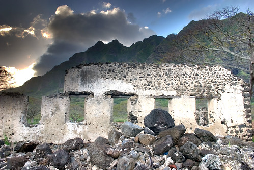
The Kualoa sugar cane refinery in Oahu began operation in 1863 by Charles H. Judd and Samuel G. Wilder. It met with little success and closed thirty years later.

Kualoa CoordinatesWhat does bird guano and sugarcane have in common? Well, historical geography often has strange bedfellows. The photo above is the Kualoa Sugar Mill, an enterprise that met with little success and was constructed in 1863.

It was owned originally by two missionary boys, educated in Hawaii — Charles H. Judd and Samuel G. Wilder. The top layer of bricks was hand-laid by Wilder himself. Both Judd and Wilder would go on to serve as illustrious cabinet members for famed King Kalakaua (the last king of Hawaii).

Judd, Purvis, and the Last King of Hawaii

The history at the mill sings. I knew it was a place that had a lot of stories to tell the moment I set foot on its stones. Constructed of igneous lava rock and meticulously hand-mortared, it’s no wonder that the place has survived 150 years of neglect.

The mill was only in operation for a very short time. In the 1860s, a young boy (probably looking to get a taste of sweet, delicious Hawaiian sugar), fell into a vat and died of severe burns soon afterwards. In the ensuing 30 years, unprecedented droughts hit the Northern Shore of O’ahu, and the cane withered (curse of the dead vat boy?)

Let’s get back to the bird guano & cugar connection (I’m getting there, I promise). After the sugar plantation failure, Judd went off to form his own enterprise after serving on the King’s cabinet (resigned due to “improprieties,” apparently linked to a less-than-flattering cartoon drawn of the King in a burlesque and related derogatory information printed in local newspapers).

Wilder, in the meantime, served only a month on the King’s cabinet (Minister of the Interior). That post apparently lasted just long enough for him to create some sweet railroad acts for himself, so he went about encircling the Hawaiian islands with successful railway routes (more on this in future blog entries).

Judd was the guano guy, but that was long before his King Kalakaua cabinet days, it was even before he built the sugar mill. It was way back in the 1850s, when him and Alfred G. Benson landed on the remote Baker Island and Jarvis Island, 2500 km south of Hawaii in 1857. At the time, Judd represented the American Guano Company (no joke) to claim the islands in the name of the United States under the Guano Act of 1856 (again, not joking). Even before then guano samples had to be collected. The results were a boon, and newspapers touted the rich guano islands as the “new El Dorado” — says the Baltimore American; “it will cover our wasted fields with golden grain.” By 1859, forty-eight islands were taken by the U.S. explicitly for their bird poop, and Judd was well on his way to building a sugar mill.

See! THAT’S the guano-sugar connection! (yeah, i know, it’s tenuous at best, but I still found it fascinating).


Richmond Shipyard #3 Slips

Geotag Icon Show on map March 6th, 2007

By Jonathan H

Richmond Kaiser Shipyard Quay
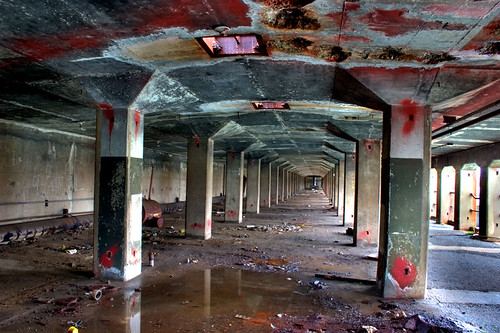
The first of five slips, or “quays,” at the Rosie the Riveter World War II Home Front National Historic Park. These semi-subterranean walkways surround the quay.

Richmond Kaiser DrydocksIn my entry on the SS Red Oak Victory ship, I told you I would return in a few weeks with the story of the Richmond Kaiser Shipyards. Shipyard number three is the most significant of the yards, primarily because it is the only remaining permanent drydock complex. Some of the other shipyards (though built earlier) were constructed to be temporary.

Today, the shipyards sit in a dilapidated state. During rains, water drips through the ceilings of the subterranean drydocks. The access stair cement is slowly decaying into the saltwater. An old crane sits across from the Red Oak Victory, near the main Kaiser warehouse. The old pumps pumped out a massive 50,000 gallons per minute if an emergency arose. They operated on an average of 11,000 gallons per minute.

HAER documentation prepared for the National Park Service mentions that each of the five basins was equipped with gates, which could block out water, allowing for the construction of the ships. Each of the whirley cranes (one of which still survives on the yard) would lift the massive gates out of the water when the ships were ready to be towed out to water.

Walking among this site was nothing short of a life-altering experience. Before descending the stairs into the subterranean drydocks, I was well aware of the cultural significance of Richmond Shipyard #3. At its peak, in 1943, Kaiser employed over 90,000 people in his four Richmond yards, who — all told — constructed 747 ships during the war. It was such an incredibly huge operation that Kaiser’s Richmond shipyards employed 10% of the wage earners in California’s durable goods industry.

An unfortunate conclusion is drawn regarding the shipyard’s demise. Dorthea Lange’s haunting portraits give us a glimpse into those most affected:

richmond-workers.jpg

When the Kaiser shipyards closed in 1945, thousands of workers lost their jobs. Today, Richmond, my hometown, once a city of success and a blue collar community that was safe to walk at night, has become a haven for gang violence and drug sales.